Warning!
The road leading up to the Swinging Bridge (F.S. 816) is in pretty bad shape, so do not attempt the trip with a small car. No need for four-wheel drive but cars that sit low to the ground will have issues. You may of course park at HWY 60 and hike all the way to the bridge (seven miles round trip.)
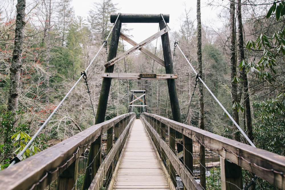
Swinging Bridge | Blue Ridge, GA
The Swinging Bridge is perhaps the easiest, shortest yet most beautiful little hikes near Blue Ridge. Being close to the Lilly pad Village, we do send many families to enjoy this amazing suspension bridge (the longest east of Mississippi). As mentioned, your hike to the Swinging Bridge is only 0.2 miles – very easy walking.The drive to the bridge will take you along (3.5 miles) on a Forest Service Road – dirt road that can on occasions be a bit rough. The short walk will take you to the Toccoa River. Whether you cross the bridge or stay on the approach side, there is lot to see.
I have many times hiked out to this destination, and spent hours just enjoying the soothing sound of the rushing waters of the Toccoa River – I have been known on occasions to take a little nap also.If you cross the bridge, you will get to a beautiful little creek where the surrounding trees offer some wonderful shady spot.
The trail is actually art of the Benton MacKaye trail system. If you continue hiking south from the swinging Bridge, your fairly strenuous walk shall take you to Long Creek Falls (I have done this hike many times and it is not recommended to novices). Hiking north from the Swinging Bridge, you will eventually end up by the Lilly Pad Village after which the trail continues to Fall Branch Falls.
Directions To Swinging Bridge
The Swinging Bridge is a popular destination for day-hikers, Benton MacKaye Trail through hikers, and paddlers making the journey down the Toccoa River Canoe Trail is the swinging bridge over the Toccoa River. This 270 foot long bridge is the longest swinging bridge east of the Mississippi River.
The bridge over the Toccoa River is located on the Benton MacKaye Trail and the Duncan Ridge National Recreation Trail in Fannin County. It was built by the USDA Forest Service in cooperation with the Appalachian Trail Club in 1977, when extension of the Blue Ridge Parkway to Kennesaw Mountain was under consideration.
Directions from the Lilly Pad:
- Take a left on Aska Road
- Take Aska to the very end – 6 miles.
- Take a left on to Newport
- Take Newport to the very end where dead ends on to Dial
- Take a right on to Dial
- Take Dial to the very end where it dead ends into HWY 60
- Take a right on HWY 60
- Drive exactly 1.4 miles
- You will see a gravel road on right, called Forest Service Road 826. There is a sign to the right here to the Swinging Bridge
- Take a right on FS 816 and take this road for 3.5 miles, until it will dead end into parking are.
- Park and take the short hike (0.2 miles) to your destination.
Scan QR Code for Google Maps Pin:
