Blue Ridge Waterfalls – Long Creek Falls
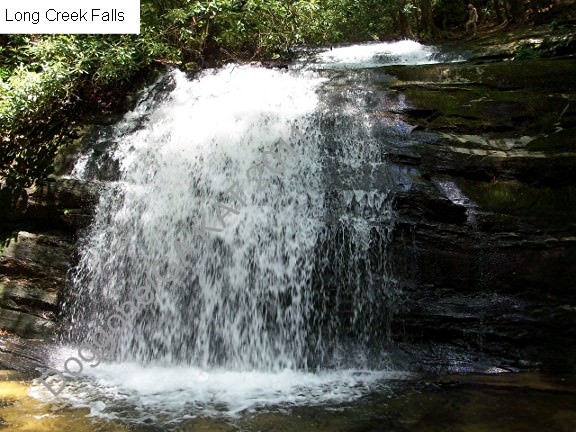
Long Creek Falls is perhaps the prettiest of Blue Ridge Waterfalls. Fall Branch Falls is second in line – just depending on how far you are willing to drive and what your expectations are as far as the length of a waterfall hike, level of difficulty and your sense of adventure.
Long Creek Falls is a leisurely two mile hike (one mile there and one mile back). Your enjoyment will start as soon as you get on to F.S. 58 – spectacular views of Nontootla Creek along side the road. Your drive might be slow spaced – not because of the road, although can be slightly challenging after a strong rain – but because of the views. The trail will intersect F.S. 58 at an area called Three Forks, because of three beautiful creeks that join there to form Nontootla Creek. Hiking will lead you along a section of the Appalachian Trail and the Benton MacKaye Trail where both trails use the same foot path – just look for the white diamond and white rectangle blazers. The views are spectacular and the hike is cool, especially once you get to the vicinity of the waterfall. There are a number of spectacular little waterfalls on the way, which are fairly difficult to access. Take your time and wait until you complete the mile.
Directions from Blue Ridge:
To get to Long Creek falls from Blue Ridge Take GA Hwy. 515 .8 mile east to Windy Ridge Road. Turn right and go .2 mile to the dead end with Old US Hwy. 76. Turn left, go .2 miles to Aska Rd. Turn right and go 13.5 miles to the end of the road. Turn right on Newport Road, go 4.5 miles. Turn left onto Doublehead Gap Road, and continue .8 mile to the intersection with USFS Road 58 on the right. Turn onto USFS 58 and go 5.3 miles to Three Forks. Noontootla Creek, a great trout stream is on your right as you go up the hill.
Directions from the Lilly Pad:
- Go south on Aska (take a left when you leave the Lilly Pad)
- Go to the end (6 miles)
- Take a right on to Newport
- Take Newport to the end (4.5 miles)
- Turn left on Double Head Gap
- Road will turn gravel
- Pass church on left and at the next three way fork take a right on to Forest Service Road 58
- Drive 5.5 miles on 58
- You will see the road widen to allow for parking
- Park, and hike on the Appalachian Trail/Benton McKaye trail to your LEFT. Do NOT hike to the right even though at this point it looks prettier 🙂
- Walk about one mile, at which point the AT and BMT will part ways. There is a sign at this point towards the waterfall.
- Enjoy the hike and scenery.
Scan QR Code for Google Maps Pin: